Big South Fork has some of the best hiking in East Tennessee.
Located on the Cumberland Plateau, Big South Fork National River and Recreation Area is packed with great hikes for just about any level of hiker – from serious, multi day through hikers to families with small kids out for a stroll in the woods.
As a Knoxville native, Big South Fork is one of my favorite places to hike.
One of the reasons I love Big South Fork is that it has so many relatively short trails that are just 1-3 miles long that lead to something fantastic—a waterfall, a rock arch, or an overlook.
I usually have about 3 miles before I need to show the kids something cool or reach a stopping point.
The kids max out at 7 or 8 miles for the day, generally speaking, so we either do one long trail with preferably several cool sights along the way or we hike several short trails.
Luckily, Big South Fork has lots of trails for us to choose from and I’ve described a dozen of our favorites here along with tips and my top choices by area.

Our 12 Favorite Big South Fork Hiking Trails
- Twin Arches Upper Loop – 1.2 miles RT, easy
- Twin Arches Lower Loop – 4 miles RT, moderate
- Slave Falls/ Needle Arch Trail – 3.1 miles RT, easy
- Middle Creek Nature Trail – 3.5 miles RT, easy
- East Rim Overlook – 0.1 mile RT, super easy
- Angel Falls Trail – 4 miles RT, easy
- Oscar Blevins Farm Loop – 4 miles RT, easy
- Grand Gap Loop – 7 miles RT, moderate
- Honey Creek Loop – 5.7 miles RT, difficult
- Blue Heron Loop – 6.5 miles, moderate
- Split Bow Arch/ Bear Creek Overlook – 1.3 miles, easy
- Yahoo Falls/ Yahoo Arch Trail – 2.8 miles Rt, easy

How I Grouped The Hikes Together Because Big South Fork Is A Large Park
I grouped my favorite trails together by area so it was easier for you to plan if you wanted to hike several of them in one day.
Big South Fork is a large park and it can take awhile to drive between some of these trails. If you wanted to hike all of these trails, you would need several days.
For instance, it takes 1.5 hours to drive from the Twin Arches trailhead off of Divide Road in Tennessee to the Yahoo Falls trailhead in Kentucky in the northern tip of the park.
But you could hike several trails in one day that are grouped together in areas, such as the hikes off of Divide Road, or on the Kentucky side of the park.
Stairs Alert! – Many of the hiking trails in Big South Fork have sections with very steep and narrow stairs in order to navigate the various rock features predominant all over the park. It makes the hiking varied and interesting but also can be tough for anyone with limited mobility, carrying a kid in a backpack, or for dogs.
If you are looking for other things to do besides just hiking in Big South Fork – check out 11 Things To Do In Big South Fork.
Big South Fork Hiking Trails On The Tennessee Side
On the Tennessee side of the park, I have grouped the hikes together in 3 areas:
The West Side Of The Park (Off Of The Divide Rd Entrance) – 4 hikes here
- 1) Twin Arches Upper Loop Trail – 1.2 miles RT, easy
- 2) Twin Arches Lower Loop Trail – 4 miles RT, moderate
- 3) Slave Falls Trail/ Needle Arch – 3.1 miles RT, easy
- 4) Middle Creek Nature Loop Trail – 3.5 miles RT, easy
Bandy Creek/ Leatherwood Ford Area – 4 hikes here
- 5) East Rim Overlook – 0.1 mile RT, super easy
- 6) Angel Falls Trail – 4 miles RT, easy
- 7) Oscar Blevins Farm Loop Trail – 4 miles RT, easy
- 8) Grand Gap Loop Trail – 7 miles RT, moderate
Southern End Of The Park – 1 hike
- 9) Honey Creek Loop – 5.7 miles RT, difficult
Hikes On The West Side Of The Park – Off Of The Divide Road Entrance
These hikes are all grouped together off of Divide Rd which is the gravel road entrance to the west side of Big South Fork. There is a big sign at the entrance from Hwy 154.
Divide Rd is a well-maintained gravel road (I drive it in my Prius all the time) but don’t speed because 1) it kicks up a lot of dust and 2), the road is multi-use so you can run into horseback riders and even wagons (true story – I have seen a covered wagon on this road and a couple of carriage drivers as well).
Directions To Divide Rd Entrance To Big South Fork
If you take 297 west from Bandy Creek Campground, it will dead end at Hwy 154/Pickett Park Hwy. You will have left the park by this time. Turn right on Hwy 154 and then keep an eye out for Divide Road on your right. Turn right and re-enter Big South Fork NRA.

Helpful Tip – If you want flush bathrooms (which none of the trailheads off of Divide Rd have), keep driving on Hwy 154 for 2 miles (5 min) past the Divide Rd turn. You will come to Pickett State Park on your left and the Visitor Center is right there.
1) Twin Arches Upper Loop
1.2 miles RT, easy/ moderate difficulty, 1-2 hours, stairs
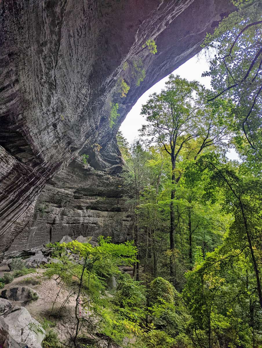
The shorter of the 2 loop trails that go to Twin Arches, the Upper Loop absolutely lives up to the hype as one of the best hikes in Big South Fork. Talk about bang for your buck!
The two arches that make up the Twin Arches (creatively named the North Arch and the South Arch) are the largest east of the Mississippi. They are one of the most famous features in Big South Fork so you should really make a point to see them.
The first time I hiked this trail with twin nine- year olds, it took us roughly 2 hours to complete the trail with lots of picture time and a long lunch break on top of the arches. Since then, I have hiked this trail probably at least 10 times and generally do it in under an hour.
The size of the arches still doesn’t get old though. And I have so many pictures because it truly is hard to capture their immensity on film but I keep trying.

Underneath the Twin Arches 
The view from the top of the South Arch in Big South Fork National River and Recreation Area 
One of the sets of stairs on the Twin Arches Upper Loop trail. This one leads up to the top of the arches.

Trail Description
From the parking lot for Twin Arches, go left at the first fork of the trail and then down the stairs. This takes you to the arches from ground level first.
Take a bunch of pictures under these magnificent rock formations, then take the stairs to ascend to the top of the arches. I think it’s more fun that way because you know what you are standing on.
If you stay right at that first fork, then you won’t realize you are walking on top of the arches until you come down the stairs that lead down from them. And you will then have to end the hike on some really steep stairs back up to the parking lot.
*Tip- You can climb all the way up to the very top of the South Arch once you ascend the stairs to the top of the arch. You will find a spectacular view up there but it is off trail. It is to the left when you come up the stairs and you have to do a small amount of rock scrambling to get up there. I would not do it with young kids or kids who like to wander off as there are no guard rails and it is a straight drop-off from the top of the arch.

Getting to the Trailhead
Once you turn onto Divide Rd, go for about 4 miles, then turn right again at the sign for Twin Arches Trailhead. Drive for about 2 more miles and the road will dead end at the parking lot for the trailhead.
The Twin Arches Loop trailhead has a nice new picnic area but only vault toilets. Those can be either fine or smell terrible depending on when they were last serviced. I have experienced both.
(See tip above about going to Pickett State Park before turning onto Divide Rd.)
2) Twin Arches Lower Loop
4 miles RT, moderate, 2-4 hours, no steep stairs
This is one of my favorite hikes out of all of them in Big South Fork. It is a spectacular trail that takes you past some very impressive rock features from the aforementioned Twin Arches but also huge rock shelters and cliff walls.
You also get to see a former farmstead site and enjoy a peaceful stroll along a creek. All in all, the Twin Arches Lower Loop Trail is just a super day in the woods.
As you can see from the images below, there are so many rock shelters and cliffs along this trail that is truly hard to keep from stopping every 10 sec to take pictures.


Trail Description
*Note – I found wildly varying mileage online, on the park maps, and on the trail signs for this hike. My mileage of 4 miles is based off of my Garmin watch. The official National Geographic map lists this hike as 3.6 miles, the NPS website says 4.2 miles, and the trailhead sign says 4.6 miles.
The Twin Arches Lower Loop starts from the bottom of the Twin Arches Upper Loop so add that 1.2 miles RT into your day if you plan on starting and finishing at the parking lot.
There is a descent no matter which way you head first, whether hiking the loop clockwise (heading towards Charit Creek) or counter-clockwise (heading to Jakes Place first).
I like to hike counter-clockwise and head to Jakes Place first as you descend past the most impressive rock features that way.
The trail between the Twin Arches and Charit Creek is just switchbacks through the woods and I prefer to save that for the end when I am tired and am making time back to the car.
But each to their own – some people like to do that section first and then take their time climbing back up to the Twin Arches on the more gradual and scenic section of the trail between Jakes Place and Twin Arches last.
Once you get to Jakes Creek (if you start heading that way first), you come to a grassy clearing where Jake Blevins used to have a cabin and farm. The logs from that homestead were moved to Charit Creek and used to construct one of the field cabins there. Now it is a great place to have a lunch break or backcountry camp as there is a stream nearby.
There is a junction with a connector trail running out to Slave Falls/ Needle Arch at Jakes Creek. These are 2 worthwhile sights in Big South Fork, although I have hiked to them via the Slave Falls Loop trail which I will mention below. I have not hiked this connector trail.
Once you pass Jakes Creek, the Twin Arches Loop trail follows along Station Camp Creek for a really nice and peaceful walk (it is fairly flat – yay!) until you get to Charit Creek Lodge.
Charit Creek Lodge is a hike-in (or horseback-in) lodge that is the only lodging inside the park boundaries besides the campgrounds. I love, love, love Charit Creek and you should absolutely look at spending the night here if you can. Click here to read my in-depth review and why I think it is worth the money.
From Charit Creek, you start your ascent back up to the Twin Arches through a series of switchbacks. Luckily this part of the trail is less than a mile long so before you know it, you are at the bottom of the arches again.
3) Slave Falls Trail/ Needle Arch Trail
3.2 miles, easy, about 2 hours
An easy hike to a large rock shelter with an 80 ft waterfall and a thin and narrow rock arch.
Trailhead
Sawmill trailhead is located right on Fork Ridge Rd and has a short connector trail leading to Slave Falls Loop trail. The trailhead is a large, open grassy area with plenty of parking but no bathrooms or potable water.
Trail Description
Take the short connector trail from the parking area to get Slave Falls Loop trail. Turn right (skipping doing the entire loop which includes Indian Rockhouse) and start your hike directly to Slave Falls, following the signs. Skipping the whole loop makes the hike 3.2 miles out and back to Slave Falls and Needle Arch.
The signs are easy to follow and will tell you where to turn to take the two short spurs out to the 80ft tall Slave Falls and Needle Arch. The trail does have some log steps and a little bit of up and down but is an easy trail even for kids to do.
Read more about Slave Falls and Needle Arch trail, including a detailed description, and lots of photos.


4) Middle Creek Nature Trail
3.5 miles, easy, 2 hours
An easy hike to some huge rock shelters, Middle Creek is a great choice for people who want to see terrific rock formations without any of the steep wooden stairs found on so many of Big South Fork’s trails.
You can see the Middle Creek Nature Loop trail on the image above for the Slave Falls Loop Trail from the Sawmill trailhead.
Trail Description
Most people seem to hike this in a clock-wise direction but I don’t think it really makes any difference. From the trailhead, turn left to go clockwise and enjoy a fairly flat walk as the trail parallels Divide Rd and Fork Ridge Rd.
Then the trail descends down under the bluff you were previously walking on and becomes much more interesting.
The trail winds past some very large rock shelters, some of which are fenced off to prevent trampling of rare plants and the glow worms only found in the rock shelters of the Cumberland Plateau.
There are often wet-weather waterfalls and the rock houses can seep water even when it is dry so this is a great hike in the winter when the water seeping can form super cool icicles.
After you pass the rock houses, you climb up some rock “steps” to get back up to the top where you follow the trail back to your car. The steps are not difficult though.
Getting to the trailhead
The trailhead is on Divide Rd, near the entrance to the west side of Big South Fork. See the trail map picture under Slave Falls.
Hikes Around Bandy Creek/ Leatherwood Ford
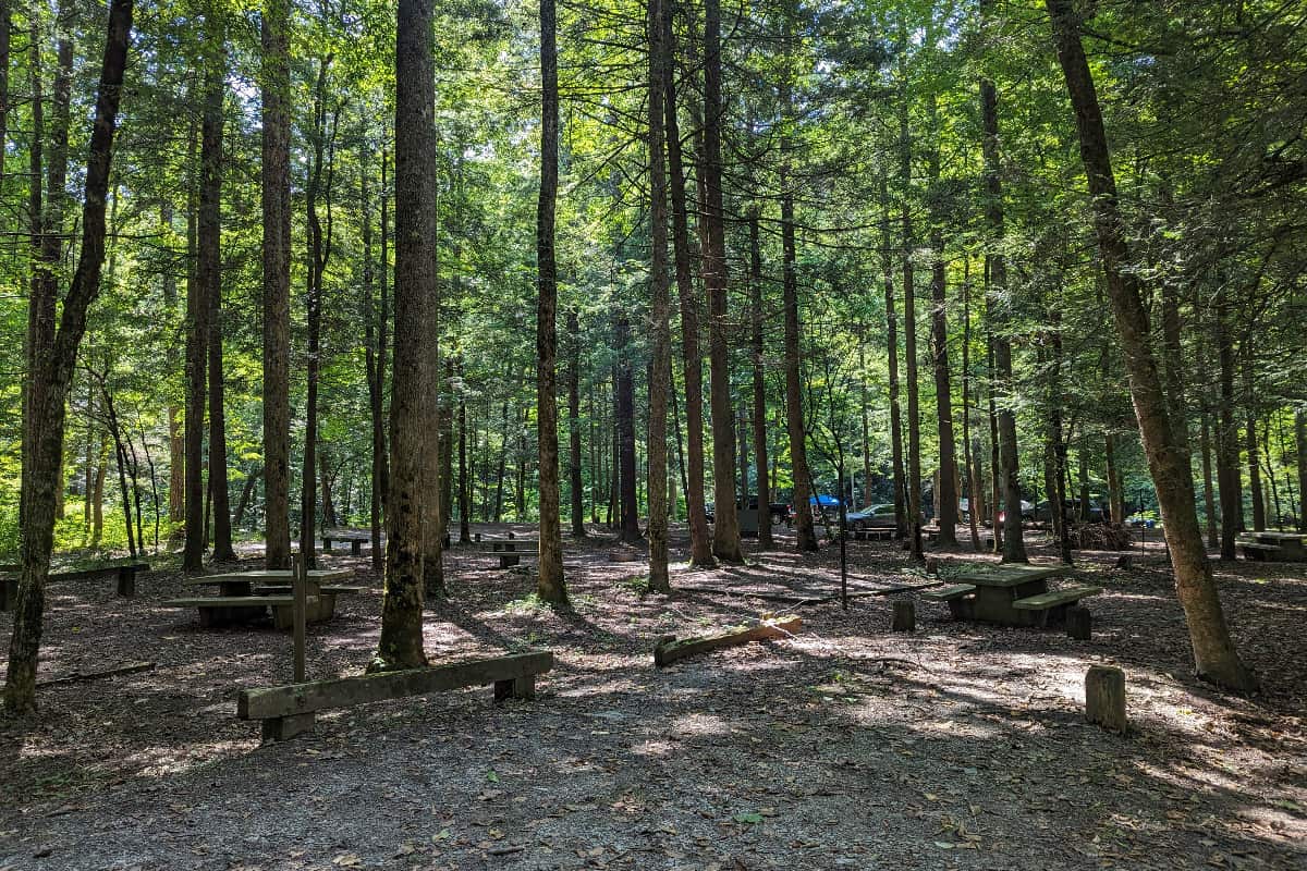
There is quite a bit to do in this area, from stopping at the nice Bandy Creek Visitor Center to camping at the large and well-kept Bandy Creek Campground.
There is also a nice picnic area by the river at Leatherwood Ford (where the road crosses the river).
Find out why Bandy Creek Campground is my favorite out of the 5 campgrounds in Big South Fork.

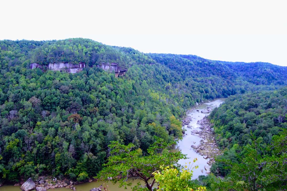
5) East Rim Overlook
0.1 mile RT, extremely easy, 15 min
You can’t get an easier hike than the one out to East Rim Overlook. From the parking area out to the overlook, it is about 300ft on a paved path. The overlook has a nice view of the canyon below.

If you are looking for more easy strolls to overlooks in the park, I list a few more in 11 Things To Do In Big South Fork | An Ultimate Guide.
6) Angel Falls Trail
4 miles RT, easy, about 2 hours
Not to be confused with the far more difficult Angel Falls OVERLOOK trail, the Angel Falls trail walks along the river until you reach the Class IV rapid called Angel Falls.
(The overlook trail climbs steeply up to the overlook at the top of the gorge. It is much more strenuous.)
Just keep in mind that Angel Falls can look far less impressive in fall when the water level is low. And it is a Class IV rapids because the dynamics of the water flow sucks boaters under making it very dangerous to navigate. Kayakers and rafters paddling down the river must portage around Angel Falls.
Trail Description
Starting from the parking area, you simply stroll along the river for 2 miles until you reach Angel Falls rapid and meet up with River Trail East. There will be a sign pointing to the rapid when you get there.
I think this is a better hike in the fall because you can see more of the river when the leaves are off but it is also a nice spring hike because you can find wildflowers.
Getting to the Trailhead
Park at the large parking area by the bridge over the river at Leatherwood Ford. There are flush restrooms at the parking area and a picnic area. You can also see the remains of the old bridge across.
7) Oscar Blevins Loop
3.6-ish miles, easy, 2-3 hours, has some stairs
The Oscar Blevins Farm Loop is an easy stroll starting from near Bandy Creek Visitor Center out to a historic farmstead that was inhabited from the 1800s until the 1970s. The trail is mostly a walk through the woods but does pass by some rock shelters and wet- weather waterfalls.
*I like this trail but I really only hike it if I am camping at Bandy Creek. I like being able to hike to things right from the campground and avoid the car for a day. It is not a trail I tell people to do if they only have one day in the park and haven’t done the other trails listed here. Skip down to my top 3 trails below to see those recommendations for if you only have a short time in Big South Fork.
Trail Description
You can go clock-wise or counter-clockwise, it doesn’t really matter. The rock shelters and more interesting sections of the trail are on the southern half of the trail, so if you go clock-wise, you will come to those first.
Then you will join up with a mountain bike trail for about a mile before splitting off again and then coming to the Blevins Farm. It is about 2 miles from the parking area to the farm going clockwise.
Once you get to the farm, you can walk around for a bit to see the original settler cabin and corn crib from the 1870s as well as the newer 1950s farmhouse and large barn.
You can’t go in the buildings but it is nice to walk around and enjoy the meadow and hopefully blue sky. There is a small sign to tell you a bit of the history.
From Oscar Blevins farm, it is a shady 1.6 mile walk back to the parking lot if you are going clockwise. The parking area is about 150ft above the farm so you do have to climb back up some on this section but it really isn’t too bad.
Getting to the Trailhead
Drive past the Bandy Creek Visitor Center and entrance to the campground. Go about 0.25 miles and you will see the parking area for the trailhead on your left. Or you can easily walk there if you are camping at Bandy Creek (see my description).


8) Grand Gap Loop
7 miles RT, moderate, 3-5 hours, shared trail with mountain bikers
This is a popular mountain biking trail in Big South Fork but many hikers also do this trail because of its nice overlooks of the gorge below.
Trail Description
Like every loop you can hike clockwise or counter clockwise but in this case, I would recommend counter- clockwise, heading to the Angel Falls Overlook first. That way, if you get tired or the trail is busy, you can turn and head back after seeing that famous overlook. It is about 1.6 miles away from the trailhead.
If you keep going past the Angel Falls Overlook, you will get views as you walk along (sometimes right along the edge!) the cliffs on this side of the canyon. Fall/ winter have the best views in my opinion.
The back half of the loop is really just a walk in the woods which is why lots of people just hike out to the Angel Falls overlook and back.
Getting to the Trailhead
From Bandy Creek, drive down Duncan Hollow Road until you come to Alfred Smith Road. Turn right and go a little less than 2 miles down this road until it ends.

The turn-off for the gravel Duncan Hollow Road is right in the middle of Bandy Creek Campground.

Hikes Around The Southern End Of Big South Fork
9) Honey Creek Loop
5.7 miles RT, difficult, 5 hours
Honey Creek has been voted one of the best trails in TN and is only 5.7 miles long with minimal elevation gain so it doesn’t sound too hard at first.
But much of the trail follows along a small creek, involving wet crossings, rock scrambling, and wayfinding as you look for blazes and arrows spray-painted on rocks. Many people love the challenge.
Read this description if you are interested – he has great GPS mapping and lots of pictures.
- Tip #1 – Go through the cracks in the rocks and not around.
- Tip #2 – Download an offline map to follow with a GPS device or your phone’s GPS. It will help to make sure you don’t get too far off trail.
- Tip #3 – The rangers recommend you hike the trail counter- clockwise in order to see the trail markers.
- Tip #4 – Make sure you give yourself plenty of daylight! It is hard enough to find the trail on the backside of the loop without doing it in the dark too.
- Tip #5 – Don’t hike after a heavy rain or when it is icy.
- Tip #6 – Bring extra socks as your feet will get wet.


Big South Fork Hiking Trails On The Kentucky Side
I have grouped the hikes on the Kentucky side of Big South Fork into two main areas:
Hikes Around The Blue Heron Mining Community
- 10) Blue Heron Loop Trail – 6.5 miles, moderate
- 11) Bear Creek Overlook/ Split Bow Arch – 1.3 miles, easy
Hikes Around The Northern Tip Of The Park
- 12) Yahoo Falls + Yahoo Arch – 2.8 miles, easy
Hikes Around Blue Heron
The Blue Heron Mining Camp is one of my favorite places in Big South Fork. It is a former mining camp that has been turned into an Interpretive Center and walking trail around the former town.
It is well worth exploring to see this important part of Big South Fork’s history. To find out more about this amazing (and free!) place, read my Exploring Echoes Of The Past In Fascinating Blue Heron Kentucky.
There are some fantastic hikes in the area around Blue Heron, including several you can reach by taking the old coal train trestle over the river – Catawba Overlook and Dick Gap Overlook were both recommended to me by a ranger and are on my list for my next visit.
If you think this area of the park sounds great and are going to spend most of your time here, then look at camping at nearby Blue Heron Campground.
10) Blue Heron Loop Trail
6.5 miles, moderate, 3-5 hours
This is possibly my favorite hike in Big South Fork after the Twin Arches Lower Loop. It has fabulous views over the gorge, a peaceful stroll along the river, and a climb through one of the cool rock formations that the park is so known for.
If you do the hike as well as take the free self-guided tour around Blue Heron Mining Community, expect to spend the whole day. But what a day!


Trail Description
You can start this trail up on the plateau where the official trailhead is but I prefer starting at the Blue Heron Mining Community which is much lower. That way you start the trail on a climb but you finish with a downhill and then a walk along the river back to the start.
If you begin at the trailhead up on the plateau, you will finish with a climb near the end. So up to your preference.
If you choose to begin at Blue Heron Mining Community, I would start the trail heading uphill to the Blue Heron Overlook. Near the top, you will climb through the “Cracks in the Rocks,” a neat rock formation with the trail going right up the middle.
Then you will pass by the two overlooks – Blue Heron and Devils Jump overlooks – and I recommend taking the short detour out to both of them. These have some of the best views of the park.
Eventually you will descend down from the plateau back down to the river and then walk along it back to Blue Heron.
Getting to the trailhead
From Stearns, Kentucky, you would take State Hwy 742/ Mine 18 Rd for about 20 min all the way to Blue Heron Mining Community at the end. There is a large parking area with restrooms at Blue Heron, as well as a vending machine area open seasonally.
11) Split Bow Arch/ Bear Creek Overlook
1.3 miles, easy, 1 hour
This hike combines two sites into one easy hike. Park at the Bear Creek Overlook parking lot off of the gravel Bear Creek Rd – it is a decently large parking area with a vault toilet so you won’t miss it.
Hike the 0.7 mile lollipop loop to Split Bow Arch (there are some stairs through the arch itself) and then hike the easy 0.3 miles out to Bear Creek Overlook, one of the best places to watch the sunset in Big South Fork.
The hardest part of this hike is getting there as it is a bit off the beaten path. It will take you 20 minutes to drive there from Blue Heron Mining Community as the last 3.5 miles is on a well- maintained gravel road.


Hikes Around The Northern Edge Of Big South Fork
12) Yahoo Falls/ Yahoo Arch
1.2 mile RT loop + 1.6 miles RT to arch, easy/ moderate, 1-2 hours, stairs
When we came around the corner to walk behind the falls, I couldn’t stop saying “How cool is this??!!” At 113 feet, Yahoo is the tallest waterfall in Kentucky and is pretty darn scenic.
This is one of my favorite hikes ever and certainly one of the best for a huge payoff after a short investment of time. The loop trail to the falls is about 1.2 miles and not too strenuous except for the steep metal stairs at the end.
Trail Direction- Go Counter-clockwise
If you go counter-clockwise and walk along the bluff on top of the falls first and then walk down to the falls second, then the steep stairs come at the end as you climb back up towards the parking lot. This is my preferred way.
If you go clockwise and take the left fork near the beginning of the trail, you descend the steep stairs first and then walk up a slow incline to get to the top of the bluff.
I actually think it is easier to go up the steep stairs rather than down so I like to go counter-clockwise.
Also, the top of the bluff is a bit anticlimactic after you have seen the falls so I like to save the falls for the second half.
Yahoo Arch
Definitely add in the 0.8 mile spur to Yahoo Arch. It is a bit of an uphill but the arch and the humongous overhang next to it are worth it. Super large and a great spot for a picnic.


Getting to the Trailhead: From Bandy Creek Campground, you will drive east on 297 out of the park to Oneida and turn left onto Highway 27. Drive north into Kentucky and keep an eye out for signs to Yahoo Falls.
You will turn left onto route 700. (GPS works well in this area and I recommend it because you will drive through some backroads until you re-enter the park.)
Once you are in the park, keep an eye out for the big wooden signs for trailheads. Yahoo Falls is a popular hike and the way is well signed.
The parking lot has a picnic area with about 8 or 9 sites that are very shaded and separated from each other. Nice new flush bathrooms at the trailhead as well.
Even More Hikes
The NPS website has a good list of day hikes in the park if you want more ideas.
My Top 3 Hikes
1) Twin Arches Upper + Lower Loop – roughly 5.2 miles total, moderate. I think this hike sums up everything awesome about Big South Fork and would be number one choice if you could only do one hike.
2) Blue Heron Loop Hike – 6.5 miles total, moderate. This is my second favorite hike in Big South Fork because I love the views from the top of the plateau and visiting Blue Heron Interpretive Center at the start of the hike.
3) Yahoo Falls/ Yahoo Arch – 2.8 miles RT, easy. I think Yahoo Falls is one of the prettiest waterfalls in the southeast so I love this hike.
* Bonus Hike * If you are a little more adventurous and are comfortable hiking using GPS and a downloaded trail map, then definitely do Honey Creek Loop. Pack extra socks because you will get wet and make sure to talk to a ranger or study the map to get an idea of where you are going. Download an offline map as well to your phone.
Easiest Hikes With Kids In Big South Fork
1) Twin Arches Upper Loop – 1.2 miles RT, easy, does have some steep stairs.You can’t beat the huge arches for getting the kids excited.
2) Middle Creek Trail – 3.5 miles RT, easy, has one section of stairs cut into the rock but they are not steep. Kids love the huge rock shelter/ “cave.”
3) Slave Falls/ Needle Arch – 3.2 miles RT, a pretty hike in the woods to a cool 80ft waterfall and a long, thin arch
4) Yahoo Falls – 1.2 mile loop, does have some steep stairs, kids will love this waterfall and you can splash in the pool at the bottom. I would probably skip the 1.6 mile RT hike out to Yahoo Arch from the falls if you have young kids.
5) Bear Creek Overlook + Split Bow Arch – 1.3 miles total, easy, small section of stairs. A short hike to an impressive arch and combined with a short hike to one of the best overlooks in the park.
7 Hiking Tips For Big South Fork
1) Watch out for rattlesnakes. I have seen 2 rattlesnakes here (in lots of years of hiking) but there are tons of signs about them around the park. So be alert and don’t let your dog stick their nose in leaf piles on the side of the trail.
2) Download an offline map so you can use GPS, especially if you are doing a less popular or well- marked trail. All Trails is great for this but you can use Google Maps in a pinch.
3) Buy an official trail map too from the Visitor Center. I use mine all the time. It never runs out of battery at inopportune moments (looking at you phone). 😉
4) Talk to a ranger at a Visitor Center to get current trail conditions if doing a longer hike or less well traveled one. Or just because the rangers are nice and there is free WiFi at the Bandy Creek Visitor Center.
5) Bring bug spray.
6) Bring lots of water. It gets hot in the summer.
7) Be BearWise. Black bears live in the park and can frequent some of the more popular trails because of some hiker’s poor practices. Don’t be that hiker! Pack out your trash (even things like apple cores, I know they decompose but they teach bears to like people food).
More Information To Help You Plan Your Big South Fork Trip
HIKING: Besides this post, also read Hiking Slave Falls and Needle Arch Trail.
Things To Do: Start with 11 Things To Do In Big South Fork, or check out Exploring The Echoes Of The Past In Blue Heron if you are interested in a recreated mining town and how it impacted this area (plus a very cool old bridge).
Where To Stay In Big South Fork
If you are wanting to camp in Big South Fork, you have 5 frontcountry campgrounds to choose from. I recommend Bandy Creek because I think it has the best combination of amenities and campsite privacy.
You can also backcountry camp just about anywhere in Big South Fork and I have a backcountry site I love just off of the Twin Arches Lower Loop. I talk about it Camping in Big South Fork.
If camping isn’t you thing, then look at staying at Charit Creek Lodge in the park, a hike-inn lodge that serves amazing food in rustic comfort. I love this place and stay there at least once a year. Read A Review of Charit Creek Lodge | Find Out Why It Is An Unforgetteable Family Adventure to find out more.
And lastly, if you are looking for a quiet cabin rental for your family getaway, you are in luck as this area is teeming with vacation cabins. The Best Big South Fork Cabins is a list of my favorites for location, amenities, and price.
Final Thoughts
I think Big South Fork has some of the best hiking in East Tennessee. So many short trails to fantastic sites and so many cool geologic features – huge rock shelters, tall arches, lots of waterfalls. These are just my favorite trails so far and I am sure that I will keep adding to my list over the years!
Happy Trails – Amanda


Thank you x 1 million for this invaluable information. We are planning a trip there this October and I will use your list for our trip. I cannot wait and your descriptions make everything even more exciting.
I am so glad it was helpful! Don’t hesitate to reach out if you have questions and I hope you have a great trip! October is a beautiful time to go.